Best Hiking Trails and Trailheads in Agoura Hills Santa Monica Mountains
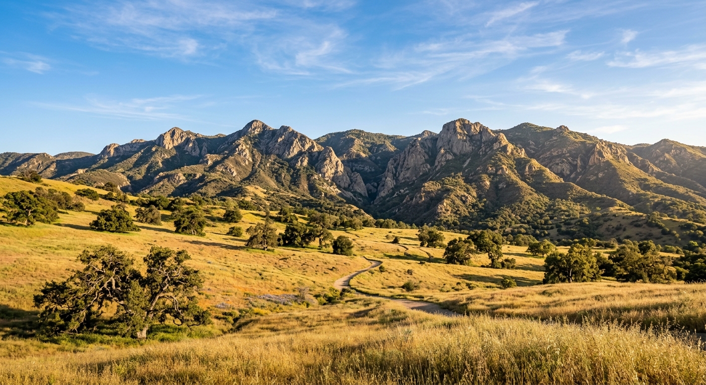
Agoura Hills · Community Photo
From sun‑drenched oak savannas to rugged crests, this guide spotlights the best hiking trails in Agoura Hills and the most accessible agoura hills trailheads, offering options for every skill level across the Santa Monica Mountains hiking network. Whether you seek a family‑friendly loop or a challenging ridge ascent, the scenery of iconic canyons and towering peaks awaits.
Agoura Hills – A Natural Launchpad
Nestled between the Santa Monica Mountains National Recreation Area and the rolling Simi Hills, Agoura Hills offers a diverse gateway for hikers of every skill level.
Year‑Round Accessibility
The region’s Mediterranean climate means most hiking trails remain open throughout the year, from cool winter mornings to sun‑filled summer evenings.
Rich Biodiversity
Explorers can wander through chaparral peaks, oak savannas, and shaded creek corridors, encountering native wildlife and seasonal wildflowers that flourish across the landscape.
Variety of Trail Experiences
Family‑friendly loops such as the Paramount Ranch Loop, praised for its easy terrain and dog‑welcome policies.
Scenic ridge hikes like the Backbone Trail to Sandstone Peak of the Santa Monica Mountains.
Long‑distance treks exemplified by the Cheeseboro and Palo Comado Canyons loop – a 10.5‑mile adventure that typically takes about six hours and climbs roughly 1,000 feet.
Streamside strolls in Malibu Creek State Park, where well‑maintained paths follow the creek through lush valleys.
Convenient Trailheads
Strategically placed trailheads within Agoura Hills provide quick access to both the coastal and inland segments of the Santa Monica Mountains, enabling hikers to launch directly into their chosen terrain without long drives.
Trail / Area | Trailhead Location | Top Highlights |
|---|---|---|
Malibu Creek State Park | Crags Rd & Grassland Trailhead | Outstanding park with many miles of well‑maintained hiking trails in Agoura Hills, offering a variety of options for all skill levels. |
Cheeseboro Canyon | 5792 Chesebro Rd | 10.5‑mile loop with 1,000 ft elevation gain; seasonal trail statistics show it is best in spring, fall, and winter. |
Paramount Ranch | Paramount Ranch, Agoura Hills | Easy, scenic loop trails; popular for dog‑friendly hikes and family‑friendly outings. |
Sandstone Peak / Mishe Mokwa | Sandstone Peak | Featured on the Backbone Trail as a premier ridge hike, marking a key Agoura Hills trailheads destination. |
Malibu Creek State Park Hikes: Rock Pools & Hollywood
Malibu Creek State Park Hikes
Malibu Creek State Park spans over 8,000 acres of the Santa Monica Mountains and offers more than 15 miles of streamside trails. The park’s main entrance on Crags Road provides direct access to two of its most iconic routes.
Crags Road Trailhead
From the primary parking area you can follow the well‑marked Crags Road path toward the legendary Rock Pool trail Agoura Hills. This segment leads past the tranquil Century Lake and culminates at the refreshing rock‑filled pool that has become a favorite spot for swimmers and photographers.
Continuing beyond the Rock Pool, hikers reach the historic MAS*H site hike, a preserved outdoor set used in the classic television series. The trail surface is a mix of packed earth and occasional rocky steps, making it suitable for most hikers.
Grassland Trailhead
The Grassland Trail begins at a modest pull‑out off Mulholland Highway. It is a gentle 2.6‑mile round‑trip connector that weaves into the heart of the park, offering sweeping valley views and passage through historic oak savannas.
Trailhead parking: a day fee is commonly charged, with some roadside spots available free where permitted.
Surface: predominantly dirt with occasional grass and mild inclines.
Seasonal notes: early‑spring streams may be higher, creating small crossings; later in the dry season the path is dry and fast‑running.
Additional Tips
Both routes are dog‑friendly, though dogs should be kept on leash around wildlife and near the water features. Bring plenty of water, especially during summer heat, and consider starting early to enjoy cooler temperatures and quieter trail conditions.
Rock Pool via Crags Road Loop – Malibu Creek Hike
trail that winds through easy‑to‑moderate terrain.
At the end of the hike, you'll arrive at the volcanic cliff swimming hole famously called the Rock Pool.
For more details, visit the official park page.
Distance | Elevation gain | Trailhead access | Key highlights |
|---|---|---|---|
3.5 mi round‑trip | modest, roughly a few hundred feet | Crags Road parking area with limited spaces; a short walk to the trailhead marked by signage | volcanic cliff swimming hole, shady sycamore grove, seasonal wildflower displays |
Practical Trail Tips
• Bring plenty of water to stay hydrated.
• Wear appropriate footwear for potentially slippery rocks.
• Dogs are welcome on the trail, but not allowed in the swimming pool area.
Map
Parking
Park official trailhead parking details
Explore the MAS*H Filming Site Trail
4.75‑mile round‑trip loop in Malibu Creek State Park, moderate difficulty. Noted for the historic military ambulance and the rusty signpost featured in the TV series.
Distance | Elevation gain | Key highlights |
|---|---|---|
4.75 mi round‑trip | moderate | historic military ambulance prop, rusted signpost, dramatic canyon backdrop |
Practical Trail Tips
Wear sturdy shoes suitable for canyon terrain. Bring plenty of water. Dogs are welcome on the trail but should stay away from the historic prop area.
Map
Trails
Park official trail information
Grassland Trail: Easy Connector to Malibu Creek State Park
Grassland Trail – a 2.6‑mile round‑trip connector trail accessed from Mulholland Highway.
It offers easy terrain across gentle rolling hills and bursts of spring wildflowers.
Distance | Elevation gain | Trailhead access | Key highlights |
|---|---|---|---|
2.6 mi round‑trip | modest, gentle rolling hills | Mulholland Highway parking area | oak savanna vistas, Santa Monica Mountain peaks, spring wildflower displays |
Trail Tips
Park at the designated pull‑out on Mulholland Highway.
Bring plenty of water, especially on hot days.
Wear sturdy shoes; parts of the trail can be rocky.
Dogs are welcome on the trail, but keep them on a leash.
Map
Details
Trailhead: Mulholland Highway
Region: Los Angeles County
Resources
Official Trail Information
Cheeseboro Canyon Trailhead & Palo Comado Canyon Views
Cheeseboro & Palo Comado Canyons
The primary Cheeseboro Canyon Trailhead is located at 5792 Chesebro Rd, Agoura Hills, CA 91301. Parking is free and the lot provides restrooms, picnic tables, and drinking water.
From this trailhead hikers can access several of the most‑visited routes in the area.
Cheeseboro Canyon Trail – a shaded oak‑savanna corridor that winds toward Sulphur Springs, covering a 10.5‑mile loop with roughly 1,000 ft of elevation gain.
Modelo Trail – a scenic ridge hike in Agoura Hills that offers expansive views across the Conejo Valley and the surrounding Santa Monica Mountains.
Both routes are popular dog‑friendly hikes, with dogs required to stay on a leash.
Trail runners, day‑hikers, and mountain bikers alike enjoy the mix of oak woodlands and ridge‑line scenery that defines the Palo Comado Canyon experience.
Cheeseboro Canyon Trail Etiquette and Safety
Explore the 10.5‑mile loop through oak savannas and ridgelines, but remember trail etiquette: keep dogs leashed, step aside for horses, and pause when you hear cyclists descending.
Sunny gravel sections can host rattlesnakes, so watch your footing and stay alert. The trailhead at 5792 Chesebro Rd, Agoura Hills, CA provides access to over 4,000 acres of open space.
Adhering to trail safety Agoura Hills best practices helps everyone share the fire roads and singletracks responsibly.
Paramount Ranch Trails and Sandstone Peak Backbone Trail
Paramount Ranch Trails
Paramount Ranch trails have long served as a historic movie set, offering a network of easy, family‑friendly paths that welcome walkers of all ages. The Backdrop Trail, Coyote Canyon Loop, and the classic Western Town routes showcase the ranch’s iconic scenery while keeping the terrain gentle.
Because dogs are allowed on the grounds, these routes are popular among pet owners looking for dog friendly hikes agoura hills outings.
Backdrop Trail – a short stroll that weaves past iconic set pieces.
Coyote Canyon Loop – a gentle loop with open vistas and historic signage.
Western Town paths – easy, flat segments that echo classic Western film backdrops.
Sandstone Peak Backbone Trail
For those seeking a more rugged adventure, the Sandstone Peak Backbone Trail leads to the summit of Sandstone Peak, the highest point in the Santa Monica Mountains at 3,111 feet. From the peak, hikers can enjoy panoramic 360‑degree views that on clear days stretch to the Channel Islands and downtown Los Angeles.
The nearby Mishe Mokwa Trail Loop, accessed just south‑west of Agoura Hills, adds volcanic rock formations such as Balance Rock and Split Rock to the experience, offering a taste of the range’s dramatic geology.
Summit of Sandstone Peak – expansive vistas and iconic ridge line.
Mishe Mokwa Trail Loop – rugged terrain with notable rock features.
Backbone Trail connection – links the loop to the broader 67‑mile mountain corridor.
Trail Finder – Agoura Hills
Discover the best hiking trails in the Santa Monica Mountains. Filter to find your perfect route.
Results
Trailhead Parking and Trail Safety in Agoura Hills
Parking & Access
For trailhead parking Agoura Hills visitors, the National Park Service sites at Cheeseboro and Palo Comado Canyon and Paramount Ranch are free. The main lot for Malibu Creek State Park, a California State Park, charges a $12 day‑use fee and also accepts California State Park passes.
Key trailheads:
Cheeseboro Canyon Trailhead – 5792 Chesebro Rd, Agoura Hills, CA 91301.
Paramount Ranch Trailhead – located within the historic Western Town area of the ranch.
Malibu Creek State Park – access via the Crags Road trailhead.
Seasonal Considerations
Summer heat in the inland canyons often exceeds 90°F. Hike early morning or late afternoon and carry 2–3 liters of water per person. Winter and spring bring lush green hills and flowing creeks, offering cooler conditions and vibrant scenery.
Wildlife & Nature
Typical encounters include Southern Pacific rattlesnakes, coyotes, deer, and poison oak along shaded creek beds. Staying on established trails helps protect both hikers and the delicate ecosystem.
Leave No Trace & Dog Regulations
Dogs are welcome on NPS lands such as Cheeseboro and Paramount Ranch when kept on a six‑foot leash. Backcountry trails in Malibu Creek State Park restrict dogs, so check signage before entering. Overall, follow Leave No Trace principles: pack out all trash, stay on designated paths, and respect wildlife.
Practical Hiking Tips
These hiking tips Santa Monica Mountains emphasize preparation:
Check the current weather forecast and trail conditions before heading out.
Bring layered clothing to adapt to temperature changes.
Use a map or GPS app to stay oriented, especially on longer routes like the Backbone Trail.
Trail Safety
Good trail safety Agoura Hills practices include:
Inform someone of your planned route and expected return time.
Carry a basic first‑aid kit and a charged cell phone.
Be aware of wildlife activity and keep a safe distance.
Many hikers point to the Rock Pool area in Malibu Creek State Park, where the historic MAS*H filming site adds a touch of movie‑making history to the scenery.
For those chasing the most sweeping vistas, Sandstone Peak— the highest point in the Santa Monica Mountains at 3,111 feet—offers epic summit views via the Backbone Trail.
What is the best hike in the Santa Monica Mountains? The answer often highlights Sandstone Peak for its elevation and panoramic outlook.
Dog‑friendly hikes in Agoura Hills include the trails in Cheeseboro and Palo Comado Canyons, where leashes up to six feet are required, as well as the loop trails at Paramount Ranch.
Dogs are not permitted on backcountry sections of Malibu Creek State Park, so hikers should check trail restrictions before heading out.
Trailhead parking in Agoura Hills varies by site. The Cheeseboro Canyon and Paramount Ranch trailheads provide free NPS parking.
Malibu Creek State Park’s main entrance requires a standard daily vehicle fee, while the Grassland Trailhead offers limited roadside parking along Mulholland Highway.
Late fall through spring delivers mild temperatures, verdant hillsides, and flowing creeks, making for comfortable hiking conditions.
During the summer months, hikers usually start early to avoid the intense valley heat.
Sun protection—sunscreen, hat, and sunglasses.
At least 2 L of water per person.
Sturdy, ankle‑supporting footwear.
Offline map or downloaded GPS tracks.
Basic first‑aid kit.
Layered clothing for fluctuating coastal‑mountain temperatures.